


GPS Logger

GPS Logger介绍
BasicAirData GPS Logger 是一个简单的应用程序,用于记录您的位置和路径。
这是一款基本且轻量级的 GPS 追踪器,专注于准确性,并着眼于省电。
它离线工作(没有互联网连接),它没有集成地图。
如果您在设置中启用 EGM96 高度校正,此应用程序在确定正高(海拔高度)方面非常准确。
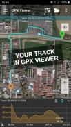
您可以记录您的所有行程,使用任何已安装的外部查看器直接从应用内跟踪列表中查看它们,并以多种方式以 KML、GPX 和 TXT 格式共享它们。
该应用程序是 100% 免费和开源的。
入门指南:
https://www.basicairdata.eu/projects/android/android-gps-logger/getting-started-guide-for-gps-logger/
它的特点:
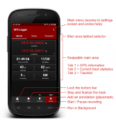
- 现代的用户界面,具有低消耗的深色主题和选项卡式界面
- 离线录制(该应用程序没有集成地图)
- 前台和后台录制(在 Android 6+ 上,请关闭此应用的所有电池监控和优化)
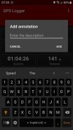
- 注释的创建同时记录
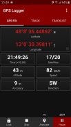
- GPS信息的可视化
- 手动高度校正(添加整体偏移)
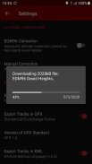
- 自动高度校正,基于 NGA EGM96 地球大地水准面模型(您可以在设置中启用它)。如果您的设备无法访问 Internet,您可以按照以下简单教程手动启用此功能:https://www.basicairdata.eu/projects/android/android-gps-logger/application-note-gpslogger/manual-设置的-egm-高度校正-for-basic-air-data-gps-logger/
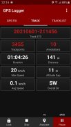
- 实时轨迹统计
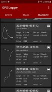
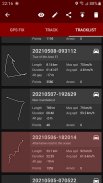
- 显示录制曲目列表的应用内曲目列表
- 使用任何已安装的 KML/GPX 查看器直接从曲目列表中可视化您的曲目
- 以 KML、GPX 和 TXT 跟踪导出
- 通过电子邮件、Dropbox、Google Drive、FTP 等以 KML、GPX 和 TXT 格式进行跟踪共享
- 使用公制、英制或航海单位
用它来:
☆ 跟踪您的行程
☆ 进行准确的静态和动态测量
☆ 添加您的地标
☆ 记住你见过的最好的地方
☆ 地理标记您的照片
☆ 与您的朋友分享您的曲目
☆ 协同 OpenStreetMap 地图编辑
语言:
这个应用程序的翻译是基于用户的贡献。每个人都可以使用 Crowdin (https://crowdin.com/project/gpslogger) 自由地帮助翻译。
常问问题:
如果有任何问题,您可能会发现阅读常见问题(https://github.com/BasicAirData/GPSLogger/blob/master/readme.md#frequently-asked-questions)会有所帮助。
重要笔记:
在 GPS 记录器中,始终在应用程序处于前台时访问(启动)位置,然后在后台也保持活动状态。在 Android 10+ 上,应用“仅在使用应用时”需要位置权限。它不需要“一直”权限。
根据您的 Android 版本,如果您想在后台可靠地运行 GPS 记录器,您必须禁用所有电池优化。例如,您可以在 Android 设置、应用程序、GPS 记录器、电池中验证是否允许后台活动并且未优化电池使用情况。
附加信息:
- 版权所有 © 2016-2022 BasicAirData - https://www.basicairdata.eu
- 有关其他信息,请参阅 https://www.basicairdata.eu/projects/android/android-gps-logger/
- 该程序是免费软件:您可以根据自由软件基金会发布的 GNU 通用公共许可证条款重新分发和/或修改它,许可证的第 3 版或(由您选择)任何更高版本。有关更多详细信息,请参阅 GNU 通用公共许可证:https://www.gnu.org/licenses。
- 您可以在 GitHub 上查看和下载此应用的源代码:https://github.com/BasicAirData/GPSLogger
- 首次启用 EGM96 自动校正进入设置屏幕时,从 OSGeo.org 网站下载大地水准面高度文件。 (文件大小:2 MB)。下载后,无需进一步的互联网连接即可使用它。
GPS Logger - 版本3.2.3
(11-12-2024)
GPS Logger - APK信息
APK版本: 3.2.3程序包: eu.basicairdata.graziano.gpsloggerGPS Logger的最新版本
其他版本


同类应用


